
Project Report 1
Project Report 1 for smARtcar
-by Gaurav Dhage and Gaëtan Coisne
Current state:
The first focus of our project is getting data from a maps API and using it to display visual direction pointers to the user in Argon. We have chosen the Google maps API for this project. We are able to retrieve the route between two locations using this API. Currently this work is being done in a separate environment independent of Argon to avoid tackling multiple issues simultaneously. On the Argon side, we are able to use two latitudes and longitudes and generate a virtual path between these two coordinates. Currently this path is being shown in the form of floating cubes and an arrow. We are currently in the process of integrating the maps data and the Argon visual navigation module. Although the modules are able to exchange all the data necessary for plotting the path, some issues encountered during the testing have delayed the exact visual feedback that we had predicted. Nevertheless, we are optimistic enough to believe that the predicted functionality will be part of the app in the near future.
Work in progress: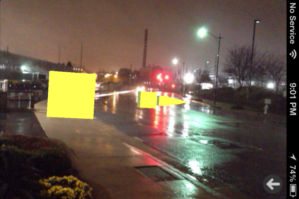
The above screenshot shows a sub part of the path to the destination. The larger cube near the screen represents the users current location. The path to the destination, Ikea in this case, involves taking a right turn at the signal. We obtain this data from Google Maps and place the cubes as intermediate checkpoints to reach the destination. Currently the direction seems slightly askew than expected and we are investigating the causes.
Current Issues:
We have encountered some pitfalls which we are yet to overcome. To set the user destination we will need to get input from the user inside Argon. We are currently unable to find any means for doing so and that is something we are working on. Three.js automatically prevents the program from creating duplicate copies of the same mesh objects, possibly for performance reasons. We are working on ways to clone arrows and use multiple direction guides from the same base meshes. Another issue that we faced is that Argon crashes when the number of virtual objects is large like say plotting 100 cubes. We are now planning to manage the virtual objects on screen so as to use the available resources sparingly. We expect all these issues to be sorted out by the end of this week.
Contributions:
The work distribution within the team was that Gaetan worked on the Google APIs to obtain the path information in a format required by the project. I on the other hand, was stuck with the nuances of Argon focusing on plotting the path. Gaetan was successful in getting the data as we had wanted. On the display side we were able to interpolate the coordinates obtained for the path to the destination and plot checkpoints along the way. There is still room for improvement in this department.
Future plans:
The current week we will be focusing on making the two different modules described work together and remove/workaround the issues that we are currently facing. The following weeks we will work on getting interesting information about places along the user’s route and showcasing it back to the user in different ways. The recent launch of the Google Field Trip app has been quite exciting as it shows current market interest in location aware AR technologies.
Channel:
You can test our current progress by opening the following link in Argon:http://mimos.test.sagz.in/smartcar1.html .
You may have to change the source and destination in the code to somewhere near your location.
Comments are closed.